Another week gone by between posts! Not what I intended, when I started this.
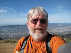
Anyway, I did Mt Williamson yesterday - it's up in the Angeles National Forest, above Islip Saddle - it is NOT the Mt Williamson in the Sierra Nevada's, with a height of over 14k. This one has a height of about 8245. Islip Saddle is the same starting point as the hike I did with the group LAST Wednesday. And this was with the same group. A good hike - not very long - my GPS said I only did about 4.5 miles - but a good climb - the last half mile quite steep - and the elevation added to the workout.
I need to do some more research, but I found one note that says you get 5% less oxygen for every 1000 feet in altitude. So if I nornally hike at, say, 3000 feet, and now I am at 8000 feet - that 25% less oxygen. So it makes sense that I would feel like I was working harder, or needing more rest, on a hike like this. And it also says I need to do MORE of them!
Back to the hike - I did wimp out a little bit. I got to the top of Mt Williamson. From there, some of the people hiked on a ridge to a couple of other "bumps" - one of them even seemed a little higher than Mt Williamson. I kind of started to go with them - but there were a lot of rocks, and a little dip (that I would have to climb on the way back), and then the climb to the higher bump - and I was already beat, and had achieved my objective - so I decided just to wait for them. And as I rested, I got my strength back, and said to myself "great - you wimped out here - so it means you will have to come back and do the whole thing all OVER again, so you can do the bumps!" WIMP!
But, still, it was a good hike. Nice views to the north east of ... not sure what exactly. Supposedly, the San Andreas fault was visible below us - but no one could point me at a specific feature. The map shows Highways 138 and 18, running from Pearblossom to Victorville. Mostly a lot of empty space. But we could see it really well! Except for the haze, of course.
That's it for today. More, soon.
Thursday, June 25, 2009
Thursday, June 18, 2009
Mt Islip from Islip Saddle via Windy Gap

Well, yesterday I joined the group I mentioned on Wednesday, on a hike pretty far up Angeles Crest Highway. You go past Mt Wilson, past Charleton, where Vetter is, past Mt Waterman and Buckhorn campgroups, through a couple of tunnels - to the spot where Ca route 39 - still closed, and unmarked - meets up with CA route 2. That's Islip Saddle. From there, its a real ncie hike up to Mt Islip - steep at the beginning, steep at the end - several options -remains of a cabin and the foundation of a fire lookout tower at the top - all in all, a very good day!
The group was about 22. They were originally a bunch of retirees from Hughes in the 1980's, who decided to hike together. I gather the group has grown and shrunk over the years. They hike every Wednesday morning. I had hiked with them once about 2 years ago - a hike from Chilao to Vetter that I never completed that time. I have done it myself since then. But this was my forst time with the group since that time. They were very friendly and welcoming, and I had a great time.
The picture above is of the hike using Google Earth. I probably would not - and SHOULD not - do this on my own - so it was great to go with the group, and add another of the Sierra Club 100 Peaks to my list.
Tuesday, June 16, 2009
Group hike tomorrow!
As I have mentioned, I hike alone almost all the time - partly because I like the solitude, partly because I can do it whenever I want, partly because I cannot necessarily find anyone who wants to hike when I want to (not that I have looked very hard).
But there is a group I know of that hikes every Wednesday morning, and I am joining them tomorrow for a hike to Mt Islip in Angeles National Forest. I hiked with then once before - I was NOT ready for that hike - but I will tell that story anotehr time. For now, I am nervous - about hiking with new people, about not embarrassing myself - worrying what should I wear (will it be too much? too little?), what should I carry (same questions) .... what am I, a teenage girl??
The biggest technical concern is that we will be starting at about 7500 feet elevation. I have only done a few hikes at anything like that altitude - and its not much compared to people who hike at 10, 12, or 14K - but I am worried about how the lower oxygen will effect my stamina. But its a preety short hike - less than 6 miles, I think - and only 1500 or 2000 ft elevation (it was a little unclear).
Saturday, June 13, 2009
Several hikes to report
I cannot believe it has been almost a week since my last post. I guess I have been concentrating on some computer problems - which distracted me from POSTING, but not HIKING!
Since my last post, I have done Hostetter to Verdugo Peak twice more - I guess that is my fallback hike, when I cannot think of what to do - but I also rediscovered a hill I had done partially, a long time ago - the trail starting at Edmore St. in Sun Valley, and going up the same Verdugo Motorway that extends all the way to Verdugo Peak, and then down to Beaudry, the other end of the Verdugo Mountains, in Glendale.
I had climbed from the Edmore trail head probably a year ago - and I wanted to do a quick hike this past Thursday - I figured I had about 2 hours before I had some other things I needed to do. I remembered the trail as fairly steep, so I thought it would be a good, quick, tough hike. And it was - but I managed to go further in one hour outbound, than I had in a somewhat longer time last year. (I had been geocaching last year, so that may have slowed me down. But I am also in better shape, now.)
As a matter of fact, at the end of an hour, I found myself at the picnic table above the Stough Nature Center in Burbank. I had been up there many times before, from the Burbank side - it's a great spot - and I knew the trail from there led to Edmore - but I thought of it as a long way off. So it was really surprising to find myself standing there.
One reason it was so surprising is that it was very foggy and damp - and I did not really know where I was - did not see any landmarks - until I reached a high spot just as my time ran out - then I saw a bench on the trail that looked familiar - one of the benches from the Burbank Rotary Club (Thank you, Rotarians!). So I figured out where I was - turned around - and there was the picnic table! It is off the trail a few feet.
Anyway, since my time was up, I turned around and headed back.
I did the same hike this morning - had the same fog and cold - used my GPS this time - 5.9 miles in 2 1/4 hours - which was actually a little slower than 2 days ago - about 2.1 hours. But I guess I stayed longer at the top - at the picnic table - this time - ate some trail mix, drank some water - put on a shirt for a little warmth, and headed down.
I was glad I had not just wimped out this morning, and skipped the hike!
Sunday, June 7, 2009
Hostetter in La Tuna Cyn yesterday
Just an easy hike yesterday - up the Hostetter fire road in La Tuna Canyon, to Verdugo peak (same destination as the Beaudry hike a week ago). Lots of people since it was Saturday - the parking area was almost full, and I was rearely out of sght of others - not my favorite hiking experience.
No hike today - should I? Shouldn't I? I decided to go to Starbucks and think about it. Where I proceed to consume unnecessary calories in the form of a breakfast sandwhich, despite having had breakfast (grapefruit and oatmeal) at home.
Yesterday, the weather started out OK - some clouds, with sunlight poking through in places. Almost forgot - I took a panoramic photo set with my cell phone cam - I need to upload them to my PC and assemble them. I use a free, open-source program called Hugin - not as fast as the utility that came with my Canon camera - but Hugin should handle my cell phone pictures, and it wasn't 100 meg of bloated software.
Back to the weather - as I rested at the top, it started to get cloudier - then REAL cloudy - dark clouds - decided to hustle down the hill in case it started to rain. Which also got me to thinking about what "pack" I use - the waist pack I had on has NO storage - so no rain jacket, no extra layer (altho the rain jacket would fit in my pocket, if I had thought it was necessary).
On the way down the hill, we had a little excitement. First I heard some fire engines - coming down Tujunga Canyon. They turned west on La Tuna - toward the parking area - sirens stopped - so I wondered if they were handling something nearby. Next, there was a helicopter circling aound - big, red - looked like an emergency transport. Then - the helicoper LANDED on the TRAIL - about 1/2 mile above me - where I had been just a few minutes before! There had been no indication of the problem then ... I talked with 2 people coming up the trail, and, when I mentioned the fire engines earlier, one of them said they were on the trail below us. So SOMETHING was going on!
I walked down a little further, until I could see the fire engines. They were right at the bottom end of a steep firebreak that people sometimes take - I had done down it twice, deciding the second time that saving 10 minutes by using it, was NOT worth the risk of falling and killing myself. Just then, I could see some people - including firemen - coming down the firebreak. The firemen were helping a group of people - I think I had seen them earlier - including 2 young kids. I was REALLY surprised anyone would take those kids down that steep hill. Of course, it does not look that steep at first ... anyway, the kids were not injured. I found out at the end of my climb that one of the women had injured her arm, and that had prompted the rescue call.
Like I said, a little excitement today!
Friday, June 5, 2009
Hiking alone / what gear to carry
No hike today - raining this morning, feeling lazy, not much sleep last nite, and I hurt my back on the long hike 3 days ago. Exercise is good for an achey back, but ... here I am sitting at Starbucks, where I ate what I *thought* was fairly low cal - a mini zucchini walnut muffin - turns out it is 390 calories! 27 grams of fat!
Anyway - about hiking - I hike alone almost all the time. I know that's not the smartest move - but we are mostly talking about here in town, on well-traveled trails - altho not THAT well traveled on a weekday. And I have done the same on some more remote (for me) trails - for example, the peaks I have climbed in Angeles National Forest - Vetter, Hillyer, etc.
Now, I do always tell a friend, Gloria, where I am going, and when I will call her back - and she would start calling people if I did not call when expected. And I do usually carry a decent amount of water and snacks, a whistle, an extra shirt, etc. Not all of what are called The Ten Essentials - things you should ALWAYS carry when hiking, in case of emergency. But hopefully it's enough to keep me alive until help arrives.
But lately, I am going a little more minimalist on my gear for local hikes - I have a belt that holds one bottle of water, plus a small flask I attach, and 2 small pockets - one for my cell phone, and one for a snack or two. I carry a towel - to wipe my sweaty brow! - in my quick-dry nylon cargo shorts - but that's about it. No place to carry an extra layer of clothes - which seems like almost the most important thing - for a sudden cool breeze, or a forced, extended stay (if I twisted ankle, or fell of a cliff, for example). So I am thinking of going to my larger belt pack - with room for 2 bottles of water, and I could squeeze in a shirt, or a great, very light weight rain jacket that I have - a Patagonia Houdini Full-Zip Jacket. They list for $125, but Patagonia had a special on one particular color for only $75. Like, I care what the color it is?
Now, I had been using my light-weight backpack - it was probably overkill for my short, local hikes - but my hikes are actually getting longer, as much as I can. And carrying the backpack is good exercise and good practice - and let's me carry a LOT more stuff for emergencies.
I have to admit that I am self-conscious when I carry more gear - I am on these local trails, and I see people with NO GEAR - sometimes no water, sometimes a bottle of water and nothing else. My friend Gloria says to IGNORE THEM - do what's smart - carry the gear ... and I do - but I still feel self-conscious.
I think the fact that I hurt my back on my last hike made me think about this a little more. That's never happened before - just walking down hill and all of a sudden a sharp back pain. I have had back pain before - but not just walking, even on an uneven trail. I guess I just came down too hard. But it could have been worse - what if I had been unable to make it down the hill?
So - bottom line - I need to use the bigger belt pack, or carry my back pack. Carry more water, food, extra clothes, etc. I love to hike, but I don't want to die up there - at least, not yet, and not for some stupid reason!
Wednesday, June 3, 2009
How high is a mountain?
Well, I was GOING to write today about whether the title on my picture was accurate. I am standing on Verdugo Peak, in the Verdugo Mountains - elevation 3120, according to the highest reading on my GPS. But - is that a mountain? I mean, when others are reaching heights of 14,000 ft and up, does 3120 qualify?
So I started to research - what is a mountain? Wikipedia has a nice article, and some of their example are lower than Verdugo Peak - so that made me feel good. Then I remembered that the Los Angeles chapter of the Sierra Club has a list of peaks over 5000 ft high - but they ALSO have a list of "Lower Peaks" shorter than 5000 ft. And Verdugo peak is on it! So that would seem to put and end to this question.
As a matter of fact, I have climbed a few of the Lower Peaks:
The Sierra Club lets you join the Hundred Peaks section when you have climbed 25 of the Hundred Peaks list (which actually has 275 peaks - you get a pin or something when you have climbed 100 of the 275). But I have a long way to go!
So I started to research - what is a mountain? Wikipedia has a nice article, and some of their example are lower than Verdugo Peak - so that made me feel good. Then I remembered that the Los Angeles chapter of the Sierra Club has a list of peaks over 5000 ft high - but they ALSO have a list of "Lower Peaks" shorter than 5000 ft. And Verdugo peak is on it! So that would seem to put and end to this question.
As a matter of fact, I have climbed a few of the Lower Peaks:
- Verdogo Peak
- Echo Mountain, above Alta Dena
- Rocky Peak, in the western San Fernando Valley
- Mt Zion, above Arcadia
- Vetter Mountain, with a beautiful, restored fire lookout tower
- Mt Mooney - near Vetter, but not much going for it
- Mt Hillyer - a nice climb, but not much of a "peak"
Subscribe to:
Posts (Atom)